
Why is Forst placed under “Zasieki”?
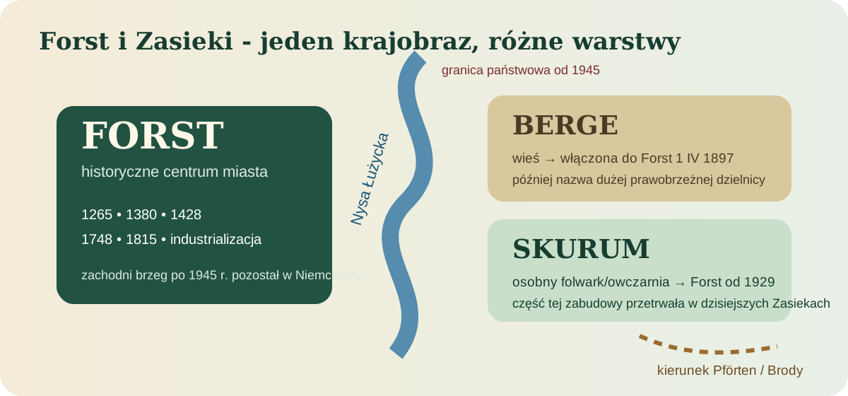
Forst (Lausitz) and Zasieki now stand on opposite sides of an international border, but before 1945 the landscape formed one urban area. One simplification must be avoided: present-day Zasieki is not simply the former “Berge”. Berge was an older village incorporated into Forst on 1 April 1897 and later gave its name to a large right-bank district. Skurum was a separate estate and sheep farm incorporated only in 1929. Post-war Zasieki covered land from both historical units.
The earliest settlement layers
The story of the place does not begin with the first written mention of the town. Brandenburg’s archaeological registers record earlier settlement traces within present-day Forst and the Neisse valley. They do not prove a simple, uninterrupted urban continuity, but show that crossings, river terraces and local routes were used long before the medieval centre took shape.
From St Nicholas to the Biebersteins
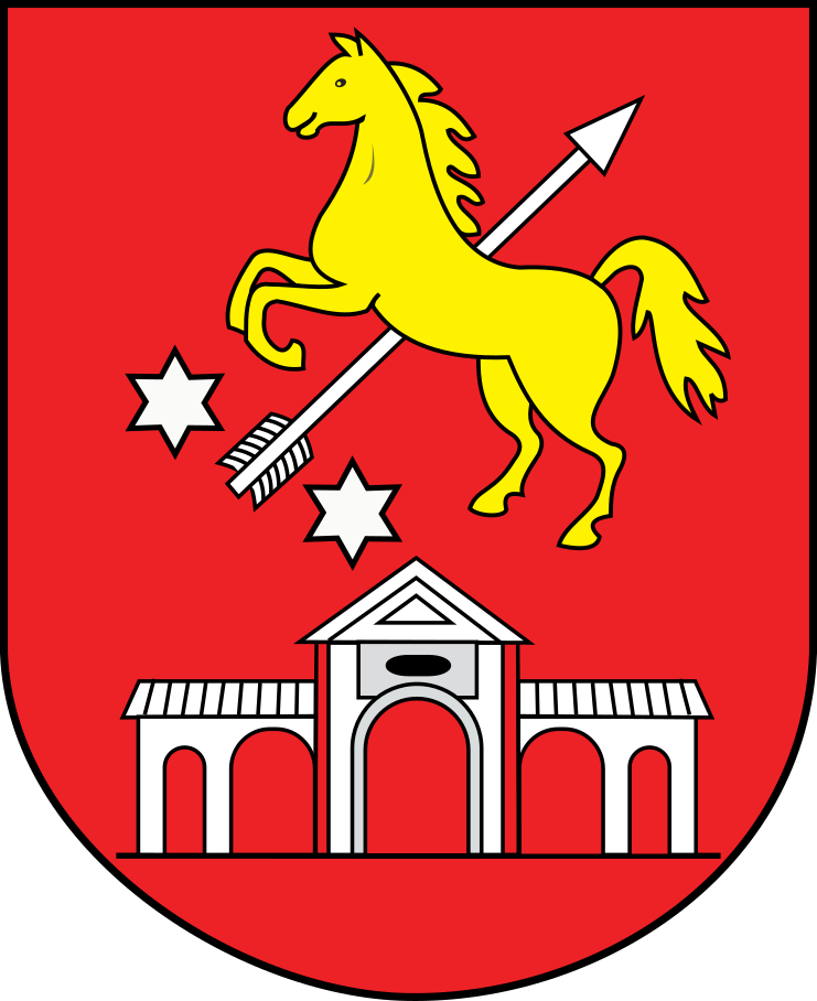
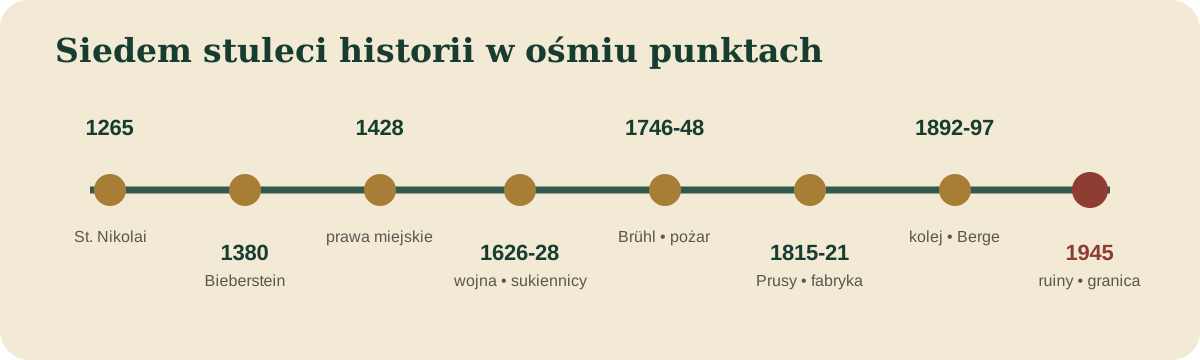
The official city chronology begins in 1265 with the laying of the foundation stone of St Nicholas’ church. In 1352 Friedrich III of Meissen granted the lordship of Forst to Katharina von Ileburg; in 1380 Hans von Bieberstein bought Forst from the Ileburg family. In 1428 Ulrich, Wenzel and Friedrich von Bieberstein confirmed the town rights. The family shaped Forst until its line died out in 1667. The modern city arms deliberately refer back to the Bieberstein coat of arms; the current official red-and-gold design has been used since 2011.
War, cloth makers and the rise of a textile town
In 1626 Wallenstein was in Forst during the Thirty Years’ War. Two years later the city chronology records the arrival of Silesian cloth makers from Lissa, Meseritz and Fraustadt. This strengthened a textile craft that would become the defining industry of Forst in the nineteenth century.
Brühl, Pförten and the fire of 1748
In 1746 Heinrich von Brühl acquired the lordship of Forst, closely reconnecting its history with Pförten, today’s Brody. A major fire devastated Forst in 1748. The town was rebuilt according to the ideas of Brühl and the architect Johann Christoph Knöffel, shaping the later Baroque centre. Forst-Pförten was therefore more than the name of an estate: administration, elites, roads and economic life were intertwined.
The “German Manchester” on the Neisse
After 1815 Forst became part of Prussia. In 1821 the merchant Jeschke opened the first factory spinning mill. Mechanisation and railways transformed the scale of production. The city’s Industrial Heritage Trail states that around 1925 there were 288 textile factories in Forst, most linked to the municipal industrial railway known as the “Schwarze Jule”. Construction began in 1892; the official city chronology lists the railway in 1893. Factories, chimneys, sidings and canals turned Forst into the “German Manchester”.
The Rose Garden — civic display and memory
The Ostdeutscher Rosengarten opened in 1913 as part of a major horticultural and industrial exhibition. It survived wars and political change and remains one of Forst’s principal symbols, linking the city’s industrial heyday with post-war reconstruction and the preservation of its cultural landscape.
1945 - ruins and a new border
The final battles of the Second World War devastated Forst. The official city chronology states that about 85 per cent of the town lay in ruins in 1945. The new border on the Lusatian Neisse cut through the former urban space: the western centre remained in Germany, while right-bank areas of Forst-Berge and Skurum became part of Poland. The Polish State Archives description of the “Akta miasta Forst” collection records that almost all buildings on the right bank were dismantled after the war and that the surviving border settlement received the name Zasieki.
East Germany, textiles and transformation after 1990
After the war, western Forst resumed textile production within East Germany’s planned economy. Plants were consolidated into state-owned enterprises, while the industrial railway continued to serve factories for decades. After 1990, lost markets, competition and restructuring caused rapid job losses and closures. Industrial monuments, heritage trails and museum collections now preserve evidence of the cloth-manufacturing city.
What does Schneider’s chronicle actually add?
Chronik der Stadt und Standesherrschaft Forst vor und nach der Vereinigung mit der Standesherrschaft Pförten
The title sought is Chronik der Stadt und Standesherrschaft Forst vor und nach der Vereinigung mit der Standesherrschaft Pförten. Johann Christoph Schneider published it in Guben in 1846; the Bayerische Staatsbibliothek digital copy contains XIV + 342 pages in Fraktur. Schneider knew both places personally: he worked in Pförten from 1802 and became superintendent and chief pastor in Forst in 1819. His chronicle covers political history as well as churches, schools, courts, police, trade, festivities and unusual events. A 1909 source edition uses Schneider for the ecclesiastical organisation of the two lordships, including the consistory in Forst and an ordinance of Johann and Abraham von Bieberstein dated 5 April 1587. The same edition cautions that some of Schneider’s statements cannot be checked because he did not cite his sources.
How we read Schneider
Dated claims are checked against municipal and archival sources. Anecdotes without cited evidence are not presented as established facts.
Documents, maps and images of the town
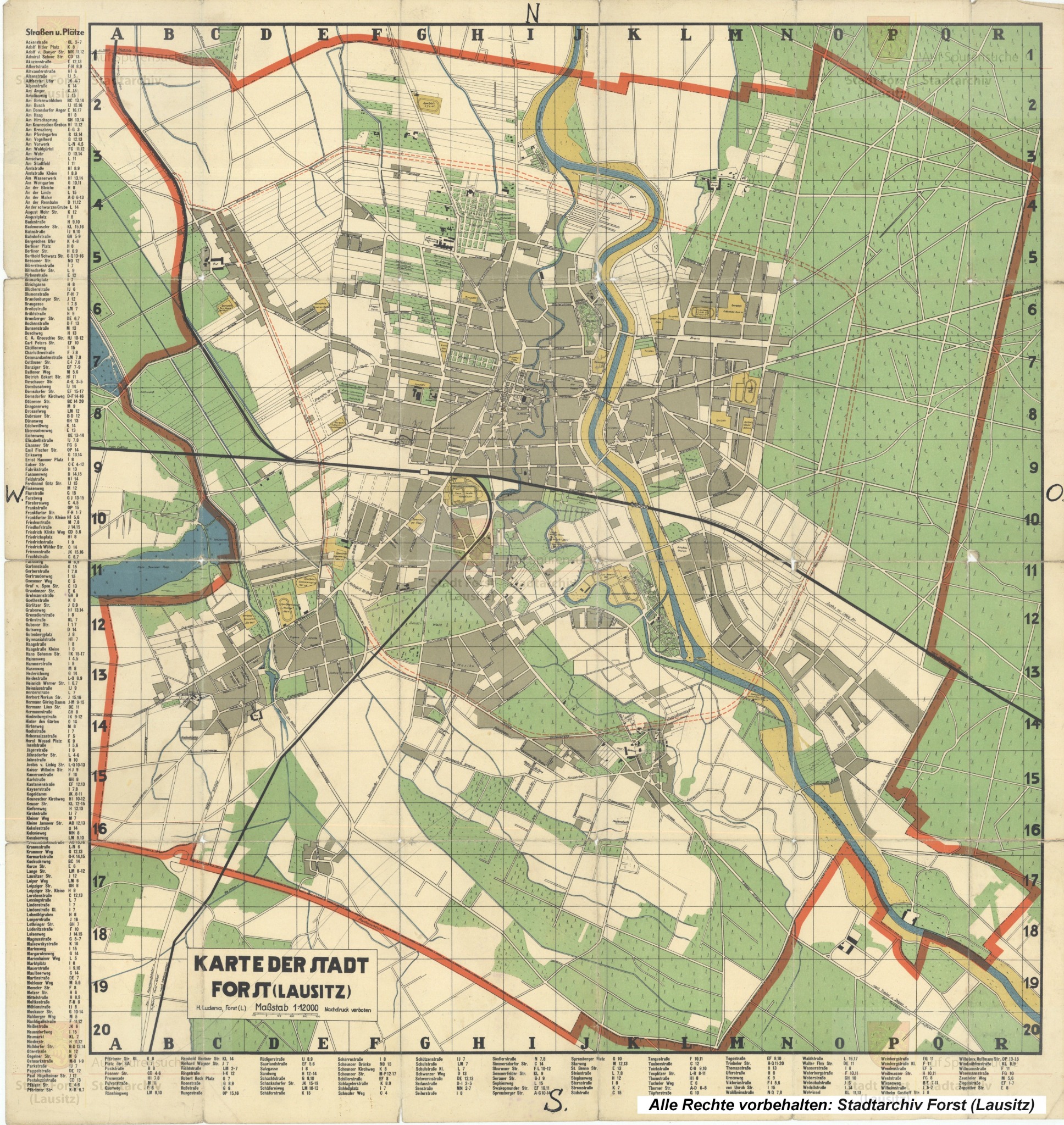
Map of Forst (Lausitz)
The pre-1945 town plan shows the shared urban space of Forst and present-day Zasieki.
Copy supplied to the Foundation; source caption: Stadtarchiv Forst (Lausitz).
Open source →
Berliner Platz, 1919
The postcard records the townscape before the destruction of 1945.
Wikimedia Commons / Zeno, public domain.
Open source →
Bismarckplatz and Georgianum, c. 1900
A representative urban space at the turn of the twentieth century.
Wikimedia Commons / Zeno, public domain.
Open source →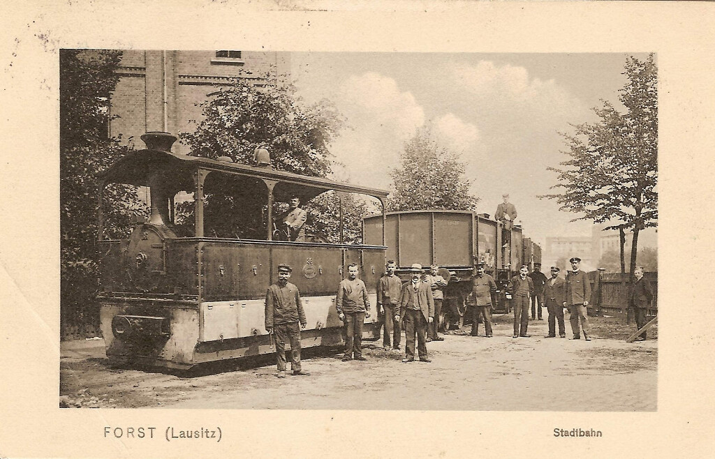
“Schwarze Jule”, 1906
Locomotive no. 36 of the Forster Stadteisenbahn with its maker’s plate.
Stadt Forst (Lausitz) / Museumsverein Forst; rights stated with the source object.
Open source →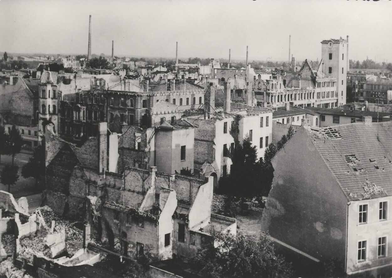
Forst after the fighting in 1945
A view from the fire watchtower conveys the scale of destruction.
Photo: Günter Wotzka, Museumsverein Forst collection; rights with the source.
Open source →New findings from municipal and archival research
Jan Klußmann’s recent study gives a more precise account of the town’s beginnings. Forst developed at a ford across the Neisse, where an eastbound salt road met a north-south route linking Upper Lusatia with Guben. The year 1265 belongs to municipal tradition; firmer documentary points are civitas in 1352, a mayor and council in 1371, and confirmation of Magdeburg law in 1428.
The research preserves a dating discrepancy concerning the beginning of Bieberstein rule: the municipal chronicle gives 1380, while the academic study gives 1385. Both are shown transparently pending closer examination of feudal and purchase records.
Opened in 1893, the narrow-gauge Forster Stadteisenbahn ran through the streets and linked the dispersed factories with the wider rail network. It operated until 1965 and its locomotives became known as “Schwarze Jule”. Textile production collapsed after the GDR period; it continued in one later museum complex until 1992, and the textile museum opened in 1995.
Population change
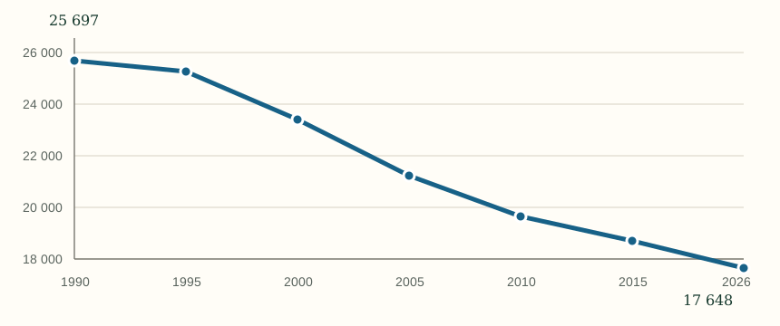
Forst’s population declined over the longer term from 25,697 in 1990 to 17,648 in 2026. The chart provides visual context for the section describing structural change after 1990.
Sources and further reading
- Stadt Forst (Lausitz) - Chronik der Stadt Forst (Lausitz).
- Stadt Forst (Lausitz) - Industriekulturpfad, tablice lokalizacyjne.
- Archiwum Państwowe w Zielonej Górze - Akta miasta Forst, 89/2083/0.
- J. Ch. Schneider, Chronik der Stadt und Standesherrschaft Forst..., Guben 1846.
- Die evangelischen Kirchenordnungen des XVI. Jahrhunderts, t. 3, 1909.
- Stadt Forst (Lausitz) - urzędowa strona herbu; Anlage 2 do Hauptsatzung - urzędowy kolorowy wzór.
- Project material: “Zasieki - Berge i Skurum” research file (Stadtarchiv Forst and Polish/German archives).